Low Cost Coastal Data Collection Using Citizen Science
This project aims to use imagery collected by the public for beach monitoring purposes, while also engaging local communities with beach management issues.
This project aims to use imagery collected by the public for beach monitoring purposes. Beaches are under a variety of pressures from issues such as climate change and rising sea levels and it is hoped that by using this simple approach a large amount of data can be collected, while also engaging local communities with beach management issues.
Project outline
This project aims to understand how useful public imagery can be for beach monitoring purposes. A number of sites are being investigated including Bournemouth, Studland, Newgale and Abereiddy. Each site has a phone/camera frame which allows members of the public to share imagery via email or Facebook. The sites at Bournemouth and Studland have been set up by the University of Bath and have been branded CoastSnap (in collaboration with partners in the University of New South Wales), while sites in Newgale and Abereiddy were set up through Pembrokeshire Coast National Park.
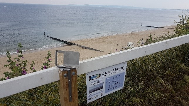
Images are aligned and rectified using a number of Ground Control Points (GCPs). These GCPs act as reference points in the image which allows conversion into an x y local coordinate system. This can allow the area to be shown in a bird’s eye view. Features within the image can then be detected and tracked allowing changes over time to be mapped. Figures 1 and 2 show the camera stations at Newgale and Bournemouth respectively, while Figures 3 and 4 show an image taken by a member of the public and an example of a rectified image (both Newgale).
Science
This project aims to allow monitoring of beach features including pebble ridge movement (Newgale), shoreline detection and curvature (Bournemouth), sand levels (Bournemouth) and river level change (Newgale). Features can be detected using changes in pixel intensities meaning the processes have a potential to be automated.
Impact
The project has a great deal of potential in engaging local communities in beach monitoring. Uptake at the majority of the sites has been good and positive feedback has been received. Surveys which try to understand the motivations and behaviours of participants will also be undertaken. By sharing images with one another, it is hoped people can be inspired to learn more about their local beach environment. Data processed using the above workflows will be presented, this should allow knowledge to be transferred to all levels of the local community.
This is the PhD project of John Hart from the Department of Architecture and Civil Engineering. Email address: J.hart@bath.ac.uk
Partners
-

University of New South Wales
-

Bournemouth Borough Council
-

National Trust
-

Pembrokeshire Coast National Park
Enquiries
Dr Chris Blenkinsopp C.Blenkinsopp@bath.ac.uk 01225386715